

Did Mount Everest grow taller?
Review
Rahul Subbaraman
Throughout our school life, we have consistently learnt that the height of Mount Everest is 8848 m. Last December, international media reported an agreement between Nepal and China over the new height of the highest point on Earth. This brought an end to decades of disputes and controversies over the previously reported heights. What was all the fuss about? Read on to find out!
Tweet
In the mountains, worldly attachments are left behind, and in the absence of material distractions, we are opened up to spiritual thought. We should be attempting to carry the spiritual experience of the mountains with us everywhere. - Sherpa Tenzing aka Tenzing Norgay
On 8th December 2020, Government officials from Nepal and the People’s Republic of China jointly announced Mt. Everest’s new height, the highest point on the Earth’s surface. This agreement marked the end of more than a decade long controversies and disputes regarding the height of the world’s tallest peak that lies along their border. Nepal is a country that almost entirely lies in the Himalayas and is blessed with eight of the world’s highest peaks - Everest, Kanchenjunga, Lhotse, Makalu, Cho Oyu, Dhaulagiri, Manaslu and Annapurna. Yet, Nepal sent its first team of surveyors only in May 2019 to measure Everest. The Chinese government’s political pressure on Nepal to accept the Chinese-measured height forced Nepal to re-measure the height and set the record straight. This makes me wonder, can the height of Mount Everest really change?
The Himalayas occur in a roughly 2500 km long stretch through Northeastern Pakistan, Northern India, Southern Tibet, Nepal, Sikkim and Bhutan. Rather than a single broad belt, they are grouped into four parallel belts from the south to the north, namely, Sub-Himalayas or Outer Himalayas - Siwalik Range, Lesser or Lower Himalayas - Himachal Range, Great or Inner Himalaya - Himadri Range, and Trans or Tibetan Himalayas. The Himadri Range of the Himalayas contains many of the world’s tallest peaks, including Mount Everest.
To understand the formation of the Himalayas, let us get familiar with a few terms. We know that the Earth is made up of several layers. Lithosphere - the outermost layer is cold, rigid and brittle. This layer is broken into fragments known as ‘lithospheric plates’, which are in constant motion (plate tectonics). When two such plates of comparable densities move towards each other (or converge as geologists like to call it), they can collide to form a mountain.
The Himalayan ranges are said to have formed from the closing of the Tethys Sea. This sea spanned between the two enormous continental bodies or supercontinents - Laurasia and Gondwana, around 152 Ma (million years ago). At about 50 to 40 Ma, the Himalayas started forming when the Indian plate collided with the Eurasian plate. This ‘convergence’ process continues until the plates get locked and can’t move any further. During this period, the mountain grows in height - ‘tectonic rise’. Everest has been growing about half a centimetre every year due to the continued India-Eurasia annual convergence of about six centimetres. So, does it keep growing? That’s where earthquakes come in!
There have been two significant earthquakes in Nepal since 1856, when Everest’s height was reported for the first time. The Great Nepal-Bihar Earthquake’ in January 1934 recorded an 8.4 on the Richter scale, and the ‘Gorkha Earthquake’ in April 2015 recorded a 7.8 on the Richter scale. Scientists have studied both these earthquakes and have observed a reduction of about half to a whole metre in the height of the Himalayas. Such a decrease in size could nearly compensate for a century’s worth of tectonic rise. This is probably why the Nepal Survey Department spent millions of Rupees on the 2019 Survey of Everest.
Curious about when Everest was measured for the first time? It was about two centuries ago, in 1823, when a team of Indian Surveyors was commissioned by the then Surveyor General of British India, Sir George Everest, to measure the entire Indian subcontinent. By 1847 the team had discovered a new peak, Peak XV, much higher than Kangchenjunga, the previously believed highest point on Earth. In 1852, Radhanath Sikdar, the team’s mathematician, established the fact with calculations. That was the first time modern calculations were employed to measure the height of the highest point on the Earth’s surface at 29,002 feet. To name the peaks, it was common to use local names like Sagarmatha (Nepali) or Chomolungma (Tibetan). Yet, Sir Andrew Waugh, the successor of Sir George Everest, recommended the peak be christened ‘Mount Everest’, honouring a man who has neither seen the peak nor was involved in its discovery.
Post Independence, in 1954, the Survey of India revised the height up to the snow cap as 29028 feet (8848 m), while in 1975, the Chinese surveyors reaffirmed the Indian measurement at 29029.30 feet (8848.13 m). The US used GPS and radar technology and declared the height to be 29035 feet (8850 m). Finally, a Chinese expedition in 2005 claimed the height to be 29017.15 feet (8844.43 m) which started a long-standing debate between Nepal and China on the official height, as Nepal used the Indian reporting.
Nearly 163 years after the first declaration of the height, a Nepali survey team headed by Chief Survey Officer Khimlal Gautam and supported by Survey Officer Rabin Karki and Guide Leader Sherpa Tshering Janbu reached the summit at 3 AM on 22nd May 2019. The team collected Global Navigation Satellite System (GNSS) observations with the receiver they carried. The GNSS Survey used 12 different stations in the Everest summit’s lower peaks for their trigonometry calculations involving 285 points. The signal receivers at each station convert the time it takes for the signals into a height measurement. As Nepal had chosen the Bay of Bengal as its mean sea level (MSL), it could use the elevation of the point on the India-Nepal border that was closest to Everest. This data was available from a previous survey conducted by India. Using trigonometric calculations to measure the elevation accurately from that point, they employed a network of line-of-sight stations placed at regular intervals until Everest was visible.
One of the significant concerns regarding the measurement of the height is to determine the top. While some parties choose the snow cap, others prefer the solid rock. Using a compact ground penetrating radar (GPR) instrument, the summit team determined the distance between the top of the snow cap to the highest point of solid rock beneath it. Ground penetrating radar utilises high frequency radio waves which are transmitted as pulses into the ground.
It seems pretty simple to think about measuring the mountain with the help of GNSS, satellite maps and other sophisticated modern pieces of equipment. Yet, Everest’s height was calculated back in the mid 19th Century when such technologies were unheard of. So how did the Indians really pull it off in the 1850s? Only after a century, in 1953, Edmund Hillary and Tenzing Norgay became the first to reach the summit. This is where the concept of trigonometry comes in. By employing a surveying instrument called theodolite, the angle of elevation to Mt. Everest’s highest point was calculated relative to a plane whose average height above the sea level was already known. One angle and one dimension or two dimensions are required to measure another dimension of the right triangle. This means that we should know the accurate distance between the point of measurement and the peak base. The measurement was done from two or more positions along the same elevation. Further, a simple calculation using the angles of elevation and the distance between the measurement positions gives the height of Mt. Everest.
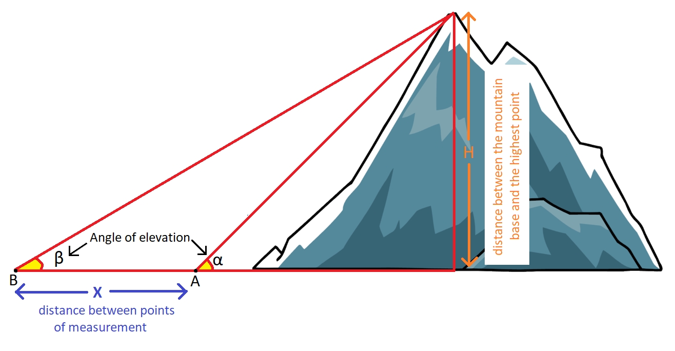 Employing simple trigonometry to measure the height of a mountain.
The Earth is a dynamic system with an active tectonic process that builds up mountains, and earthquakes that pull them down. The height of Mount Everest and the Himalayas are bound to change with time, and there will be a need to remeasure the peak. With technological advancements, the measurements could become quite effortless.
Employing simple trigonometry to measure the height of a mountain.
The Earth is a dynamic system with an active tectonic process that builds up mountains, and earthquakes that pull them down. The height of Mount Everest and the Himalayas are bound to change with time, and there will be a need to remeasure the peak. With technological advancements, the measurements could become quite effortless.
Rahul Subbaraman is a 5th Year Earth Science student who loves to work on the chemistry of rocks and melts. He harbours a child-like curiosity and is full of questions about the things around him. When he isn’t binge-watching a show or a movie, or reading a book, you can find him sharing his thoughts and his latest culinary exploits on his blog, ‘Carte Blanche’.
signup with your email to get the latest articles instantly